Uncategorized

Let the Adventures Begin!

by Jess Evans
March 13, 2018

“The FIG” in Red River Gorge, Kentucky, was my first adventure race and only race I did for several years.  The FIG was a 12-hour adventure race that had been taking place since 2002.  With the tough terrain and spectacular views, it is still one of my favorite races.

My first FIG was in 2010.  I signed up as a solo-female.  Unfortunately, I need to dig around in my memory to separate my past FIG races.  They seem to jumble together.  I think the race started with a bus ride to the trails on the east side of the highway, and ended in Beattyville.  I remember in this race the rappel section was backed up and a young woman got her hair caught in the ATC, which prolonged the back up.  I, along with a few other teams, decided to skip the rappel, hoping to find a safe route down.  It was a bit sketchy climbing down, but we made it to the road below.  Soon I was by myself again and trying to get up another ridge to a saddle where the next checkpoint sat.  Much of that race is a blur, but I do remember getting to the finish before anyone else.  The race staff was not even there yet!  Because it was my first race, I was pretty cautious and cut out a lot of the checkpoints, fearing I would be late.  Nope, I had to sit there and wait for everyone to show up.

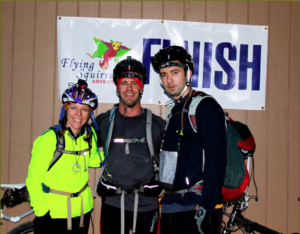
I did at least one more FIG as a solo-female until, in 2012, Stephanie introduced me to two guys from Indiana racing under the name “Off The Map”.   They were looking for a female racer to qualify for the USARA National Championships race.  In those days only Co-Ed teams could qualify for the USARA National Championship race.  I was so worried I would be slow and a terrible teammate.  However, I had a great time with Robert and George, and we qualified for the 2013 USARA National Championship race in Brown County, Indiana.  I never dreamed I would make it to the National Championships. Surely that was for far better racers than me!  The best part about that race in 2012 was that I learned I really enjoy racing on a team, and I found a great racing buddy.  I still race with Robert from time to time, when we can manage it.


Exercising at Elevation

by Jess Evans
March 9, 2018

Disclaimer: There is no scientific or medical evidence to support anything I say.  I am strictly working off of experience and anecdotal information.

I grew up in Colorado and started my athletic career above 6,000 feet, but I moved to the mid-west when I was 18 to attend college.  I became a low-lander quickly. Short visits to Colorado were disturbing because my lungs would be gasping for oxygen while doing short, easy runs.  I could run about 2 miles and then needed to stop for a breath, and running up hill was nearly impossible.  However, do not be discouraged by my tale, because I have learned that exercising at higher elevations is possible for all you low landers out there.

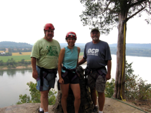
In 2015, I decided to join two friends on the Great Divide bike ride through the Rocky Mountains.  All of us lived in Ohio (a measly 1,000 feet above sea level).  The Great Divide starts in Banff, Alberta at about 4,800 feet above sea level and goes up from there.  They arrived in Alberta on a Sunday, and we were scheduled to start riding on that Friday.  Due to work, I could not join them in Alberta until Wednesday.  I arrived, put together my bike, packed my gear, and rode around the town a bit.  On Thursday we decided to get started a day early because the weather was supposed to be wet and cold Friday.  We left by 2pm on Thursday, when the day was still sunny and warm.  We had traveled about 60 miles that day and then stopped to pitch our tents.  I was so sleepy, but I learned quickly that this is how my body behaves to higher elevations.  I get so sleepy, I can barely keep my eyes open.  The next day we continued our journey riding about 80 miles.  My sleepiness did not disappear.  A few days later we rode up Cabin Pass, which is about 5,500 feet, and on our way down the other side, I got really sleepy again.  I had to stop and sleep on the side of the road for a few moments.  The crazy thing is, I was getting 8 to 10 hours of sleep a night on this ride and being sleepy during the day did not seem reasonable.

Most of us who like outdoor sports and participate in them a lot, are in good physical condition.  In my experience, if you are in good physical shape, altitude sickness affects you in minimal ways.  You may get a headache, feel nauseous, feel dizzy or sleepy. If you are biking, running, and paddling, these symptoms are not too bad to endure. You will get over them as you begin to adjust to the altitude.  For any low landers who are thinking of doing Pike’s Predicament Adventure Race, the race route stays between 7500 and 9500 feet above sea level.  My advice is to 1) arrive a few days early to acclimate, 2) stay hydrated to stave off major symptoms, and 3) take it easy during the race – give your body time to adjust.  Listen to your body too.  It is going to be a beautiful race, so stay healthy to enjoy it.


What’s up with March?

by Jess Evans
March 1, 2018

March always feels like the real beginning of race season, even though I have raced 10 out of 12 months a year.  When I sign up for a March race, I always have the nagging voice in my head saying, “did you train enough over the winter to really be in shape for this race?”  But whether I can claim I am ready or not, I really look forward to being outdoors during this time.

Past March races I have done are the Death March and Conquer the Crossroads Rogaine in southern Indiana, and the LBL Challenge and The Breakdown in Kentucky.  Definitely, the best part of all the spring races for me is being out in the woods.   This is when spring is just budding out.  I get excited about hearing the early spring frogs (wood frogs and spring peepers).  I know I will see the first signs of spring as the purple flowers from the redbud trees just start to appear.  Also, the elegant and fragile spring flowers start to gingerly make their way out of the soil. Some of the early spring flowers are Spring Beauties, Daffodils, Hepatica, and Trout Lilies.  If you find yourself in a very pristine patch of woods, you’ll see the more rare spring flowers.  It is a special time to be in the woods because life is returning.

According to Adventure Race Hub, March is bursting with adventure race life too.   There are 13 races taking place around the US – and also GodZone in New Zealand, which is on my bucket list.  Whatever may be your favorite race or your closest race, get out and do those races.  You’ll feel better.


How to Plot UTM Points

By Shawn Lemaster
February 25, 2018

We were surprised by recent surveys and discussions on plotting UTM points for races… the results say most of you actually like doing it! So by popular demand, we’ve been including this element in our longer races.

If you need to brush up on your plotting skills (or learn completely from scratch) here you go.

Mark Lattanzi nails it perfectly in his new book Squiggly Lines. This is pretty much the bible of navigation for AR, so check it out if you don’t already have it. If you do have it, flip to page 30, read three pages, and you’ll be a near-expert.

Let’s summarize how you’ll actual plot points for our races though.

First things first. You’ll need a UTM Plotter. Most ARs require a 1:24,000 scale plotter (this is the scale you’ll be using for our races). There’re two styles, Slot and Corner. Both work well, it’s just personal preference; some find the slot style a little quicker.

With plotter in hand, you’re going to receive your race map(s). These maps will have a UTM grid overlaid on them with each square equaling 1 kilometer. Along the edges, you’ll see the actual UTM coordinates for each easting line (the lines running up & down along the Y axis) and each northing line (the lines running left to right along the X axis). So, here are examples of both the Race Map and UTM Coordinates you’ll receive. Let’s try plotting the Start/Finish to the LBL Challenge this year.

Read More

My First Look at Adventure Racing

by Jess Evans
February 20, 2018

If you listened to Randy Erickson’s podcast when he interviewed me, you may already know the story of how I got into adventure racing, but I am a much better storyteller in print than verbally, so I will tell it again, with a little more flare… hopefully.

I grew up in rural Colorado on a small farm, and I played summer soccer from a young age where I ran constantly on the field.  My family would also hike and camp in the mountains regularly.  I had the foundation for someone who spends a lot of time outside.

I went to college at Purdue University in Indiana far away from the mountains of Colorado.  I majored in Anthropology with an emphasis in Archaeology. I had always loved history and had a little taste of archaeology as a child when I would dig up “artifacts” from an old abandoned school house near my parent’s home.  Archaeology is where I learned to read topographic maps.  In those days (the 1990s), archaeological sites were recorded by hand, on topographic maps (GIS was not widely in use yet). If you needed to locate that site again, you had to use the topo map to find them.  I would go out to the farm fields with map and compass in hand and pace count (in meters) to the archaeological site.  Little did I know that this skill would lead me to an exciting sport later in life.

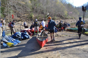
I will skip ahead about 10 years. I was at Otter Creek Park in Kentucky working in the Nature Center and the Recreation Department.  I learned how to climb an alpine tower, belay, and rappel at the park and taught visitors how to do these activities too. It was a blast!  In September of 2007, my supervisor announced that Stephanie, from Flying Squirrel Adventures, would be putting on an adventure race in the park, and I would be helping with the ropes section.  I had no idea what an adventure race was, but it all sounded fun.

That day I had the pleasure of observing an adventure race in action.  It was biking, paddling, trekking, rappelling, climbing an alpine tower, and all while using a topo map and compass to find their way around the course.  Holy moly – this was great!  Uncertainty about the sport, and all that gear, kept me as an AR volunteer for two more years, but eventually, I got up the courage to try one – “The FIG” in Red River Gorge, Kentucky.